GEOGRAPHY AND POPULATION Nkporo lies in the following Geographical Areal Graticles: Between Latitudes 5° 45 and 5° 51 North, and Longitudes 7° 44 and 7° 53' East (terminating at (buba Owutu. Using the Etitiama village, the above translates approximately into the Spot Grid of. Latitude 5° 46' 10" North, and Longitude 7° 45* S0" East. The highest elevation is the ancient Compound of Nde Nkefa, while the lowest point is around Amaekwu. 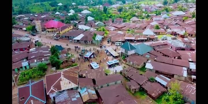 The town is settled in a semi-circular security-oriented, almost echeloned perimeter settlement pattern, which begins at the Agbaja village in the North, moving rightwards following the Ironyi stream, and terminating at the Amurie village in the South. Partly because of her early arrival, Nkporo had in ancient times established recognized boundaries with many other arrivals, including with Akaeze at Mkpeke Achi, with Unwara at Ububa (now Afia) Owutu, with the Ebam through the Nkporo brothers of Umuhu Ezechiebulu, with Igbere at Oko Mbakwo, with Oso Edda at Odu Uche (from Uche Akwuba, an Eze Amasiri), and a practically free zone with Umuenyere Elayi, with whom Nkporo had a lot of strategic cooperation, nearly similar to that with Ohafia. Nkporo is the oldest among the group of clans referred to by many anthropologists and sociolinguists as the Cross River Igbos, some of the others being Abam/Ebam, Abiriba/Ebiriba, Afikpo/Ehugbo, Akaeze, Alayi/Elayi, Arochukwu/Eruchukwu, Bende, Edda, Igbere, Ihechiowa, Item, Ohafia/Ohofia/Ohafia, Umuhu Ezechiebulu, Unwana/Unwara, and Ututu. All or most of these peoples are believed to be offspring of a common ancestor, probably known in ancient times as ife-Nta (the junior Light - cf. God, the senior Light). After the creation of the Ebonyi State in Nigeria, Nkporo became the northernmost town in Abia State, bounded in the north by the Akaeze clan, and the Oso Edda village., in the north-east by the main Edda clan., in the south-east by Ohafia., in the south by Ebiriba, Umuhu Ezechiebulu and Ebam clans, and in the West by the Item clan. Before the creation of the present Ohafia Local Government Area, to which Nkporo, Ohafia and Ebiriba belong, Nkporo, after Ohafia, was, according to the census figures, the most populated community in the then Arochukwu/Ohafia Local Government Area, officially numbering about 33,000 people in the seventies. In 2005, unofficial local estimates of the population of Nkporo were in the region of 100, 000 or a little more. The Nkporo people generally believe that they occupy one of the most beautiful countrysides in igboland in particular, and the reasons for this belief are quite substantial. First, the community is partially surrounded by protective hills. Right from the northeast, an important hill separates the people from Edda. This same hill-chain goes right round to the east, and thence to the south, such that to reach Nkporo from either Edda, Ebiriba or Ohafia, one has to ascend or descend quite a substantial number of hills and hillocks. It is only to the north, northwest, and west that one travels upon a plane surface from Oso Edda, Akaeze, and Item, respectively. Inside the community itself, the eight villages are planted upon a virtual semicircle around a big, plain and fertile Nchara that for centuries was uninhabited, but which today has turned into a new settlement by some local gentry and nouveaux-riches. Nkporo people are basically farmers, although all the characteristics associated with communities affected by colonialism are equally evident in the town and among its people. Farmlands are plenty, rich and fertile, and they stretch very far and wide. There are many living, all-season streams serving the Nkporo main town, farmlands and plantations. The main stream, however, remains the Ironyi, which sprang from around Oroni, at the Elughu hilly jungles, and passes through the main settlements and lands of Etitiama, Obuofia, Nde Nko, Ukwa, and Okwoko, with equally easy and comfortable access for the Amurie and Agbaja villages. Before, Nkporo was a thick jungle, but with the growth in population and increase in all sorts of infrastructures, so-called items of "development", it has joined in the unrelenting process of the savannization of the rich and wonderful tropical rain forests. This is indeed very unfortunate for, not only that the enormous forest and wildlife had totally disappeared., the medicinal shrubs, herbs, and allied natural products are also no more to be found. These have not only affected traditional medical practice and standards., the situation has also contributed to the people's impoverishment. Unlike before, there is no Nkporo man today who has, except in a zoo, sighted a live tiger, elephant or any of the other wonderful species that used to inundate the forests. This is not to speak of the menace of soil erosion which the uncontrolled felling of trees and erection of dwellings have combined to create, except that Nkporo had been so lucky that her soil texture and landscape had been helping. to control this menace, or at least slow its pace.  Modern Nkporo traditional governance is still based on the old system in which village Chiefs or Ezeogos were for practical democratic considerations semi-independent of the supreme Ezeaja of Nkporo, whose influence, prestige and powers derive from similar age-old traditions and methods. One other very important element of this governance is the Age-Grade system. The Nkporo people are, indeed, one of the most outstanding communities where the Age-Grade system plays a dominant role in the well-known Igbo city-states, actually, the many autonomous or so-called "acephalous" societies or village democracies of Igboland. In fact, a Sociology Professor (Nwanunobi, 1992:113), had stated that "the main importance" of this age grade system is that "such societies as the Nyakyusa, the Kikuyu, some Igbo groups such as the Ohafia, Abiriba, Edda, Nkporo and numerous other African societies entrust age grades with political responsibilities". The age grade system is, indeed, likely to continue to be the bedrock of the people's development and progress.
The Nkporo people today have gone a considerable distance in their development efforts. They have built roads across the various villages to make their town accessible to modern trade and commerce. They have established Elementary and Secondary Schools for the education of their children and those of neighbouring communities. They have built many health centers and hospitals, a general Post Office, a Community Bank, many markets and town halls, both at home and abroad., sustained free Primary education and higher-level scholarships over a long period, established telephone and other communications links to the outside world, and provided themselves not only with electricity, but cooperated in the struggle for political office with competing communities. Nkporo people had done much for themselves, and for others, but their potentials, and the very fact that they are still lagging behind some others, especially competing communities, in various aspects of development, show that they could achieve even far more if they return to the right track created and followed by our illustrious ancestors. Source NKPORO: The History of An Igbo City-State From Antiquity To The Present by Professor Obasi Igwe |